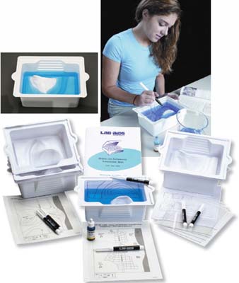
 Making and Interpreting Topographic Maps Kit
Click to enlarge
PRODUCTS BEING SOLD ARE FOR LABORATORY / EDUCATIONAL USE ONLY. THEY ARE NOT TOYS. THEY ARE NOT FOR USE BY CHILDREN 12 & UNDER.
If you are a Company, School or University we also accept Purchase Orders. Please call us at 936-727-5038. We are owned by LAB.SUPPLY Inc and any invoices or credit card charges will reflect the same.
Chemicals that we sell are NOT FOOD / USP grade. If you buy a Chemical and you are using it for Clinical / Human (Animal) Use / Application we are not liable. Again they are not for or on Human / Animal use / testing.
Making and Interpreting Topographic Maps Kit